
Landscape Visual Impact Fact Sheet
The project does not pose any extensive or major effects on the amenity of a substantial number of residences due to visual changes or effects on landscape values of regional importance.
The site and surrounding properties are recognised as significant landscapes and of environmental significance under the Yarra Ranges Planning Scheme.
The site and the proposed expansion area is bound by Canterbury Road to the north, residential housing to the northeast, Dr Ken Leversha Reserve to the east and south, and Fussell Road to the west.
The landscape to the immediate north and west of the quarry site has developed as an industrial precinct, which extends down Canterbury Road to the south-west. With the exception of native street tree planting, the industrial setting generally has a minimal and fragmented landscape presence and is in a relatively poor condition.
The Canterbury Road landscape which forms a northern boundary to the site and the eastern Fussell Road boundary is generally a mixture of indigenous and native species. Street planting blends with the quarry site buffer planting to form a vegetated edge to the site.
A Landscape and Visual Impact Assessment (LVIA) was prepared by Tract for the project. The LVIA assessed the baseline conditions of the site and surrounds, reviewing the relevant planning controls, landscape policies, character, condition and value against the project. It was found that the project is likely to have minimal effect on the surrounding environment and presents and acceptable change. The proposed extension of the quarry pit will be similar in nature to the existing quarry impacts but cover a greater area.
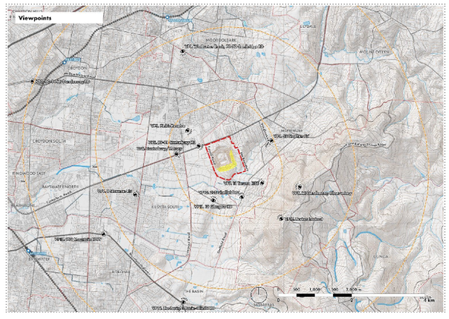
The overall landscape impacts of the project are considered low, on the basis of the size of the change and the potential for partial mitigation through revegetation. With respect to specific viewpoints, the following points are noted:
Two viewpoints provide a clear view of the existing quarry pit.
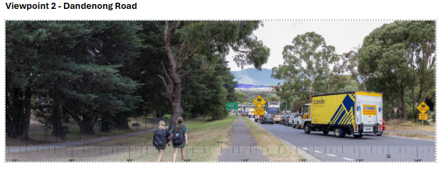
Viewpoint 2 provides a distant road-based view of the pit, but the development is only seen as a colour change in a landscape that contains a mosaic of industrial and commercial land uses with similar light or contrasting colours.
As the existing pit is already clearly evident visible from this vantage point, the level of change will be low or similar to the existing visual impact.
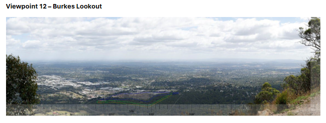
Viewpoint 12 (Burkes Lookout) provides the most prominent view of the quarry. The viewing distance allows for a detailed view of quarry features, plant buildings and related truck movements. The scenic lookout is based on a wide panoramic view that includes large scale industrial, retail and residential land uses. The diversity of land uses across the suburban area is the subject of the view and on that basis, the quarry is perceived as one component of a broader pattern of urban development, rather than as a visually discordant element. In that context, the quarry and its features and visible extent are less important in terms of view quality than its level of visibility suggest.
Two viewpoints provide slight views of the existing quarry pit.
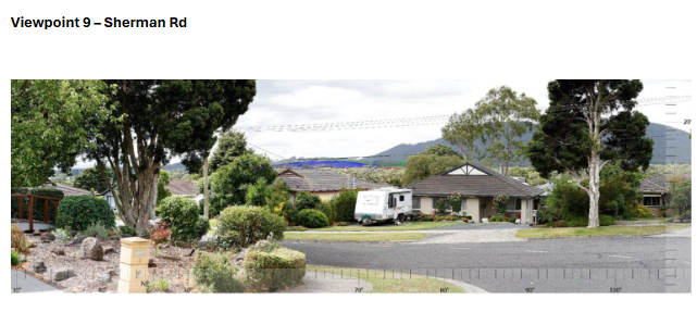
Viewpoint 9 provides a view of a thin layer of the quarry, but the development is seen as a small colour change within a dominant treed landscape.
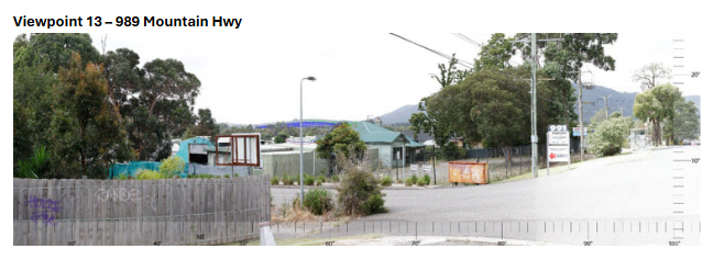
Viewpoint 13 provides a view of a thin layer of the quarry, but the development is seen as a small colour change within a dominant treed landscape. Foreground structures associated with the road system dominate the view and distract attention from the distant quarry element.
Three viewpoints provide views of the tops of existing quarry structures (concrete and asphalt plant buildings and related conveyor structure).
Viewpoint 3 provides a clear view of the top half of the concrete and asphalt plant and conveyor structures, but these structures are seen as a part of a landscape that includes dominant views of industrial sheds and sport related structures. As a result, the visible quarry features provide visible, but not dominant elements within a visually complex landscape.
Viewpoint 5 provides a slight view of the top of the concrete production building and adjoining conveyor structure. The most prominent view of on-site structures is from the south-western corner of Canterbury Road and Fussell Road. Planted bunds and site edge plantations screen the quarry facility from other viewpoints.
Viewpoint 6 provides a slight view of the top of the concrete production building and adjoining conveyor structure. Although the view of the structures aligns with the edge of the road, the general road-based view is dominated by commercial structures which create a complex and visually dominant landscape.
Overall, the existing quarry is considered to have a low level of visibility within the study area. Where views of the quarry pit or building facilities exist, they are partial views only that are visually recessive as a result of the size of the view and the more dominant visual effect of other structures and land use patterns within the field of view.
The clearest view of the existing quarry operation is from Burkes Lookout, but the impact of the view is substantially lessened by the overall nature of the panoramic view which is based on a variety of land uses and development patterns. In this context, landscape patterns and variety are the basis of the view and do not in themselves, lessen scenic quality.
The proposed stage 2 works will result in an expansion of the extent of the current pit by approximately 25%, including 9.53 Ha of remnant vegetation and 4.5 Ha of already cleared land.
The proposed development will reduce existing landform levels along the eastern and southern edges of the quarry pit and remove vegetation in the new extraction area. Existing operational patterns and plant will remain the same.
Landscape impacts will be similar in nature to existing quarry impacts but cover a greater area. The reduction in vegetation and landform change is the major landscape impact. Landscape impacts are considered to have a relatively low level of significance on the basis of the size of the change and the potential for at least partial mitigation (revegetation) over time as a result of quarry rehabilitation and likely future end use development.
Landscape buffer and site rehabilitation
Existing on-site and offsite vegetation (street trees, shelter belt tree plantations and private gardens) function as the primary visual impact mitigation measure at this time and have the capacity to provide this function into the future.
-
Retain as much of the existing EVC vegetation already existing on site, including remnant woodland vegetation and quarry buffer plantations. Ensure that all new or infill planting is based on local EVC species.
-
Supplement existing vegetation with new EVC planting, remove weeds and manage vegetation to optimise growth and climate change adaptation.
-
Retain and further develop the existing planting buffer along the Fussell Road western boundary and minimise the removal of vegetation during the construction of the Western Haul Road. Supplement the buffer with additional random spaced tree planting within the Fussell Road reservation where possible.
-
Where possible, increase the level of street tree planting in Canterbury Road within 1km of the quarry site boundary.
-
Develop tree planting where possible along the northern edge of the pit to visually isolate the processing area and concrete / asphalt plant areas and to offset effects from southern viewpoints.
-
Progressively reinstate / rehabilitate quarry faces as these become available, to soften the visual contrast and improve the visual offering. The short-term rehabilitation of the upper benches on the northern and eastern faces in particular have potential to mitigate visual impacts likely to be experienced by sensitive receptors in close proximity to the site.
Based on the findings of the Landscape and Visual Impact Assessment, it is considered that the projects visual outcomes will not have a significant effect on the Dandenong Ranges Landscape as protected by the Significant Landscape Overlay 1 (SLO1).
