
Surface and Groundwater Assessment
Surface and Groundwater Assessment Fact Sheet
An independent surface and ground water investigation has been completed for the project to understand current conditions and how future expansion might affect them.
The surface water assessment included:
- the development of a site water balance
- a review of the operating site water balance
- a calculation of the pit water lake recovery post quarrying
The ground water investigation included:
- the development of a numerical groundwater model to assess changes to Bungalook Creek baseflow, including an assessment of climate change impacts
- an assessment of impacts of quarry expansion, and
- the preparation of a monitoring plan
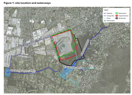
The area around the quarry includes two aquifers—one linked to Bungalook Creek and another in the volcanic rock beneath. The nearest waterway to the quarry is Bungalook Creek, which flows in a westerly direction to its confluence with Dandenong Creek. The catchment of Bungalook Creek includes urbanised and peri-urban areas and its daily flow ranges from 0.1 to 30 ML.
Flows in Bungalook Creek are derived from the following three sources:
- Groundwater contributions as baseflow, representing flow from within the saturated zone.
- Interflow, representing the proportion of rainfall that infiltrates below the subsurface and moves laterally through the soil profile before discharging to the waterway.
- Stormwater run-off or overland flow
The depth to groundwater varies across the site from over 50 m in higher areas to less than 5 m near the creek.
Groundwater seeping into the quarry collects in a sump at its base, while additional seepage emerges from fractures in the walls, fed by groundwater and surface runoff from higher batters. This water is used widely throughout the quarry for a range of industrial applications such as dust suppression and processing of the quarry product. Any excess water is discharged to Bungalook Creek under an existing EPA discharge licence.
A hydrogeological conceptualisation has been prepared to aid the description and understanding of the groundwater related processes that could be occurring on the site.
The key risks to groundwater and surface water environments from the project are associated with:
- Dewatering reducing groundwater levels around the quarry.
- Dewatering reducing baseflow contributions to Bungalook Creek.
- Changes in the catchment size/surface conditions impacting run-off and streamflows in Bungalook Creek.
The numerical modelling indicates that during dry periods, when the total streamflow is less than 10 L/s, all of the streamflow is lost as leakage due to the expansion of the quarry and associated drawdown of the water table.
During these low flow periods, the loss of streamflow in the upstream section of Bungalook Creek results in localised drawdown along the downstream section of Bungalook Creek.
The predicted drawdown along Bungalook Creek by the end of the project’s operational life is around 10 m or less unmitigated. It is limited to this because when the watertable is lowered below the creek level and there is sufficient surface flow, recharge to the watertable occurs from the creek due to this increase in hydraulic gradient. Flow may continue to occur as it could be generated from runoff within the broader catchment during high rainfall events.
Boral recognises the importance of maintaining the condition of Bungalook Creek and its associated habitat, as well as the terrestrial vegetation of the Dr Ken Leversha Reserve, as these form buffers between the operations of the site, and neighbouring residential areas.
As discussed, Boral currently reuses groundwater seepage water for onsite various uses before returning it to Bungalook Creek under their existing EPA discharge licence. Returning the volume of groundwater captured at the quarry to Bungalook Creek is As discussed, Boral currently reuses groundwater seepage water for onsite various uses before returning it to Bungalook Creek under their existing EPA discharge licence. Returning the volume of groundwater captured at the quarry to Bungalook Creek is predicted to maintain the streamflow and locally offset the modelled drawdown via streambed leakage. The modelling suggests that with mitigation, drawdown would be no greater than 5 m under Bungalook Creek.
The existing water discharge has license conditions requiring Boral to monitor the quality of water being discharged to Bungalook Creek. Boral intends to monitor the quality of this water with automated monitoring equipment. The risk of changes in the catchment size/surface conditions effecting run-off and stream flows in Bungalook Creek are considered low.
Boral is proposing to implement a surface and groundwater management plan to establish baseline conditions prior to the quarry extension. This adaptive management plan would also include monitoring triggers for Boral to implement additional actions depending upon the groundwater level response to quarrying.
Boral has also completed a field-based investigation to characterise the nature, groundwater dependence and risk posed to the potential groundwater dependant ecosystems (GDEs) caused by the project’s predicted groundwater drawdown.
The GDE assessment indicated that existing vegetation is accessing available moisture within at least the top 3.0 m of the soil profile, rather than relying on groundwater. As a consequence, the risk of terrestrial GDE occurrence in the project area is deemed to be low to negligible”.
Impacts to groundwater dependant ecosystems (GDE) due to predicted ground water drawdown are discussed more the in the Biodiversity Assessment Fact Sheet.
